


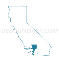
Voting District 32592, Los Angeles County, California
About
Outline

Summary
| Unique Area Identifier | 533224 |
| Name | Voting District 32592 |
| County | Los Angeles County |
| State | California |
| Area (square miles) | 1.30 |
| Land Area (square miles) | 1.30 |
| Water Area (square miles) | 0.00 |
| % of Land Area | 99.90 |
| % of Water Area | 0.10 |
| Latitude of the Internal Point | 34.08385310 |
| Longtitude of the Internal Point | -118.80958420 |
Maps


Graphs
Select a template below for downloading or customizing gragh for Voting District 32592, Los Angeles County, California


Neighbors
Neighoring Voting District (by Name) Neighboring Voting District on the Map
- Voting District 32583, Los Angeles County, CA
- Voting District 32589, Los Angeles County, CA
- Voting District 32595, Los Angeles County, CA
- Voting District 32604, Los Angeles County, CA
- Voting District 32652, Los Angeles County, CA
Top 10 Neighboring County Subdivision (by Population) Neighboring County Subdivision on the Map
Top 10 Neighboring Unified School District (by Population) Neighboring Unified School District on the Map
- Santa Monica-Malibu Unified School District, CA (108,886)
- Las Virgenes Unified School District, CA (63,947)
Top 10 Neighboring State Legislative District Lower Chamber (by Population) Neighboring State Legislative District Lower Chamber on the Map
Top 10 Neighboring State Legislative District Upper Chamber (by Population) Neighboring State Legislative District Upper Chamber on the Map
Top 10 Neighboring 111th Congressional District (by Population) Neighboring 111th Congressional District on the Map
Top 10 Neighboring Census Tract (by Population) Neighboring Census Tract on the Map
- Census Tract 8003.26, Los Angeles County, CA (4,972)
- Census Tract 8004.06, Los Angeles County, CA (2,644)
- Census Tract 8003.30, Los Angeles County, CA (942)